1. ആമുഖം
This manual provides comprehensive instructions for the setup, operation, and maintenance of your LOCOSYS LC23030-V2 High Performance GNSS Receiver. This device is designed to provide highly accurate positioning data by simultaneously supporting multiple Global Navigation Satellite Systems (GNSS), including GPS, GLONASS, BeiDou, Galileo, and QZSS. Please read this manual thoroughly before using the device to ensure optimal performance and longevity.
2. ഉൽപ്പന്നം കഴിഞ്ഞുview
The LC23030-V2 is a compact and robust GNSS receiver, often referred to as a 'GNSS mouse', due to its small form factor. It features a magnetic holder for easy mounting and connects via a USB-A cable. The device is designed for various applications requiring precise location data, such as automotive navigation, marine navigation, and high-quality NTP time servers.

Figure 2.1: The LOCOSYS LC23030-V2 GNSS Receiver, showing its compact design, integrated USB cable, and magnetic holder for versatile mounting options. The device features indicator lights for operational status.
3 പ്രധാന സവിശേഷതകൾ
- Simultaneous GNSS Support: Compatible with GPS, GLONASS, BeiDou, Galileo, and QZSS dual-band L1 and L5 frequencies.
- ഉയർന്ന കൃത്യത: Achieves 1.5m CEP (Circular Error Probable) for precise positioning.
- Adjustable Update Rate: Configurable from 1Hz to 10Hz via software, suitable for dynamic applications.
- SBAS Support: Includes support for SBAS Ranging, WAAS, EGNOS, MSAS, and GAGAN for enhanced accuracy.
- Fast Acquisition: Features free hybrid ephemeride prediction for faster cold starts and quick time-to-first fix even in weak signal conditions.
- Built-in Super Capacitor: Retains system data for rapid satellite re-acquisition.
- വിശാലമായ അനുയോജ്യത: Works with most navigation software, including open-source options like OpenCPN.
- Multi-Platform Drivers: Drivers available for Windows, Mac, Linux, and an application for Android devices.
- മോടിയുള്ള ഡിസൈൻ: Waterproof construction for reliable outdoor use.
- സൗകര്യപ്രദമായ മൗണ്ടിംഗ്: Equipped with a magnetic holder for easy installation.
4. സജ്ജീകരണ ഗൈഡ്
4.1. ഹാർഡ്വെയർ കണക്ഷൻ
- ഉപകരണം അൺപാക്ക് ചെയ്യുക: Carefully remove the LC23030-V2 GNSS receiver from its packaging.
- USB പോർട്ടിലേക്ക് കണക്റ്റുചെയ്യുക: Plug the USB-A connector of the receiver into an available USB port on your computer or compatible Android device.
- മൗണ്ടിംഗ്: Utilize the integrated magnetic holder to securely attach the receiver to a metallic surface with a clear view of the sky for optimal signal reception. The 2-meter cable provides flexibility in placement.
4.2. ഡ്രൈവർ ഇൻസ്റ്റാളേഷൻ
For Windows, Mac, and Linux operating systems, drivers are required for the device to be recognized. Please visit the official LOCOSYS website or refer to the included software CD (if applicable) to download and install the latest drivers for your specific operating system. For Android devices, a dedicated application is available.
5. പ്രവർത്തന നിർദ്ദേശങ്ങൾ
5.1. GNSS Receiver Software Interface (Windows/Linux)
Upon successful driver installation and connection, you can use compatible GNSS software (e.g., LOCOSYS GNSS Freeware, OpenCPN) to visualize and utilize the data from your receiver. The software typically displays satellite signal strength, GNSS data (latitude, longitude, altitude, fix mode), NMEA sentences, and a skyplot of visible satellites.
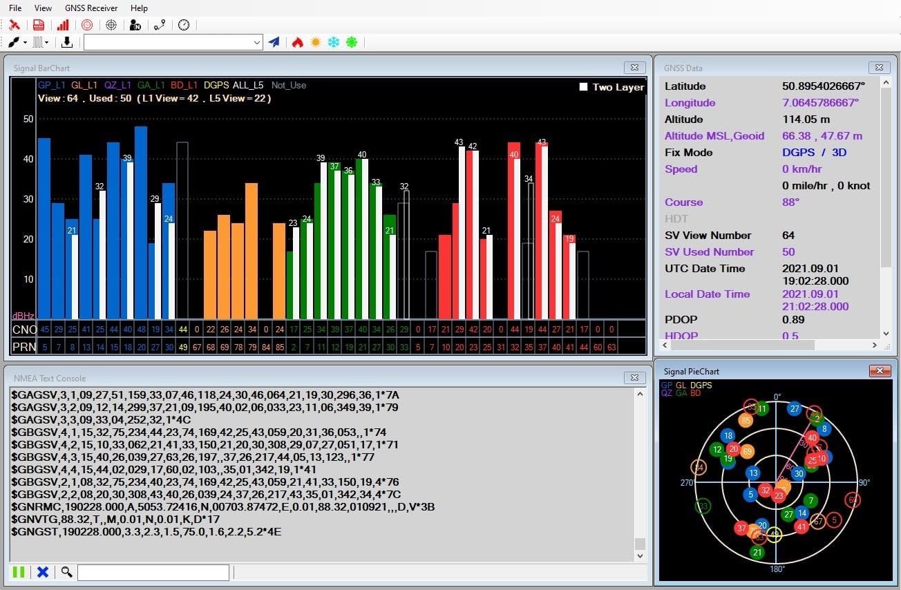
ചിത്രം 5.1: ഉദാample of the GNSS Receiver software interface, displaying real-time satellite signal strength, detailed positional data, raw NMEA output, and a graphical representation of satellite positions in the sky.
5.2. മാപ്പ് View പ്രവർത്തനക്ഷമത
Many GNSS software applications integrate map views, allowing you to see your current position overlaid on a map. This feature is particularly useful for navigation and tracking. You can often adjust the map scale and view coordinates directly on the map.

Figure 5.2: The map view within the GNSS software, illustrating how the receiver's position is displayed on a street map. Controls for zooming and showing coordinates are highlighted.
5.3. Adjusting Refresh Rate
The LC23030-V2 supports an adjustable update rate from 1Hz (default) up to 10Hz. This setting can be changed via the software's command table or configuration menu. A higher refresh rate provides more frequent position updates, which is beneficial for fast-moving applications.

Figure 5.3: Software interface demonstrating how to access the command table to modify the position fix interval (refresh rate). Users can select from various update rates, such as 1000ms (1Hz) to 100ms (10Hz).
5.4. Android Application Usage
For Android devices, the LOCOSYS GPS Mouse application allows you to connect to the receiver and view real-time GNSS data. The app typically displays UTC time, speed, course, latitude, longitude, altitude, fix mode, and raw NMEA sentences. It may also include options for logging data or integrating with Google Maps.

Figure 5.4: The LOCOSYS GPS Mouse Android application interface, displaying current GNSS parameters such as time, coordinates, and fix mode, along with NMEA data streams. Buttons for controlling the connection and logging are visible.
6 സ്പെസിഫിക്കേഷനുകൾ
The following table outlines the technical specifications of the LOCOSYS LC23030-V2 GNSS Receiver:

Figure 6.1: Detailed technical specifications for the LC23030-V2 GNSS receiver, covering supported frequencies, channel count, update rates, acquisition times, and accuracy metrics.
| ഫീച്ചർ | വിവരണം |
|---|---|
| ഉൽപ്പന്ന അളവുകൾ | 7.5 x 1.5 x 7.5 സെ.മീ |
| ഇനത്തിൻ്റെ ഭാരം | 80 ഗ്രാം |
| മോഡൽ നമ്പർ | LC23030-V2 mit Magnethalterung |
| കണക്റ്റിവിറ്റി ടെക്നോളജി | USB |
| കണക്റ്റർ തരം | യുഎസ്ബി എ |
| പ്രത്യേക ഫീച്ചർ | വെള്ളം അകറ്റുന്ന |
| നിറം | കറുപ്പ് |
| നിർമ്മാതാവ് | LOCOSYS TECHNOLOGY INC. |
| മാതൃരാജ്യം | തായ്വാൻ |
| GNSS പിന്തുണയ്ക്കുന്നു | GPS, GLONASS, BeiDou, Galileo, QZSS (L1 & L5) |
| ചാനലുകൾ | Support 135 channels |
| അപ്ഡേറ്റ് നിരക്ക് | 1Hz (default), up to 10Hz |
| Hot Start (Open Sky) | 2സെ (സാധാരണ) |
| Cold Start (Open Sky) | 28s (typical) without AGPS |
| സ്ഥാന കൃത്യത | Autonomous: 1.5m CEP |
| ഡാറ്റം | WGS-84 (സ്ഥിരസ്ഥിതി) |
| പരമാവധി. ഉയരം | < 18,000 മീ |
| പരമാവധി വേഗത | < 500 മീ/സെ |
| പ്രോട്ടോക്കോൾ പിന്തുണ | NMEA 0183 ver. 4.1 (115200 bps, 8 data bits, no parity, 1 stop bits) |
7. പരിപാലനം
To ensure the longevity and optimal performance of your GNSS receiver, follow these maintenance guidelines:
- വൃത്തിയാക്കൽ: മൃദുവായതും ഉണങ്ങിയതുമായ തുണി ഉപയോഗിച്ച് ഉപകരണം തുടയ്ക്കുക. കഠിനമായ രാസവസ്തുക്കളോ ഉരച്ചിലുകളുള്ള ക്ലീനറുകളോ ഉപയോഗിക്കുന്നത് ഒഴിവാക്കുക.
- സംഭരണം: Store the receiver in a cool, dry place when not in use, away from direct sunlight and extreme temperatures.
- കേബിൾ കെയർ: Avoid bending or kinking the USB cable excessively to prevent internal damage.
- ഫേംവെയർ അപ്ഡേറ്റുകൾ: Periodically check the LOCOSYS website for any available firmware updates to ensure your device has the latest features and performance improvements.
8. പ്രശ്നപരിഹാരം
If you encounter issues with your LC23030-V2 receiver, refer to the following common troubleshooting steps:
- No Satellite Fix:
- Ensure the receiver has a clear, unobstructed view ആകാശത്തിൻ്റെ.
- Verify that the device is properly connected to the USB port.
- Check if the necessary drivers are correctly installed for your operating system.
- ഉപകരണം കണ്ടെത്താത്ത സോഫ്റ്റ്വെയർ:
- Confirm driver installation. Try reinstalling drivers if necessary.
- Check the device manager (Windows) or equivalent for proper recognition.
- Ensure the correct COM port is selected in your GNSS software.
- കൃത്യമല്ലാത്ത സ്ഥാനനിർണ്ണയം:
- Relocate the receiver to an area with better sky visibility, away from tall buildings or dense foliage.
- Ensure the device is stationary if a static fix is desired.
- Verify that SBAS (WAAS/EGNOS) is enabled in your software if available in your region.
- ഇടവിട്ടുള്ള കണക്ഷൻ:
- നിങ്ങളുടെ കമ്പ്യൂട്ടറിൽ മറ്റൊരു USB പോർട്ട് പരീക്ഷിക്കുക.
- യുഎസ്ബി കേബിളിന് കേടുപാടുകൾ സംഭവിച്ചിട്ടില്ലെന്ന് ഉറപ്പാക്കുക.
- Avoid electromagnetic interference from other electronic devices.
9. വാറൻ്റിയും പിന്തുണയും
The LOCOSYS LC23030-V2 GNSS Receiver comes with a 2 വർഷത്തെ വാറൻ്റി വാങ്ങിയ തീയതി മുതൽ, നിർമ്മാണ വൈകല്യങ്ങൾ ഉൾക്കൊള്ളുന്നു. വാറന്റി ക്ലെയിമുകൾക്കായി നിങ്ങളുടെ വാങ്ങിയതിന്റെ തെളിവ് സൂക്ഷിക്കുക.
For technical support, driver downloads, or further assistance, please visit the official LOCOSYS webസൈറ്റിൽ ബന്ധപ്പെടുക അല്ലെങ്കിൽ അവരുടെ ഉപഭോക്തൃ സേവന വിഭാഗവുമായി ബന്ധപ്പെടുക. കോൺടാക്റ്റ് വിവരങ്ങൾ സാധാരണയായി നിർമ്മാതാവിന്റെ വെബ്സൈറ്റിൽ കാണാം. webസൈറ്റ് അല്ലെങ്കിൽ ഉൽപ്പന്ന പാക്കേജിംഗ്.


